Firefighters Contain Table Mountain Blaze But Remain on Guard
There’s no mistaking the tension in the air around Table Mountain fire hotspots. The mountain looked like a battleground mere days ago, with flames marching from the thick canopies of Newlands Forest straight towards the heart of Cape Town. Now, the immediate danger seems to have faded—but vigilance is far from over.
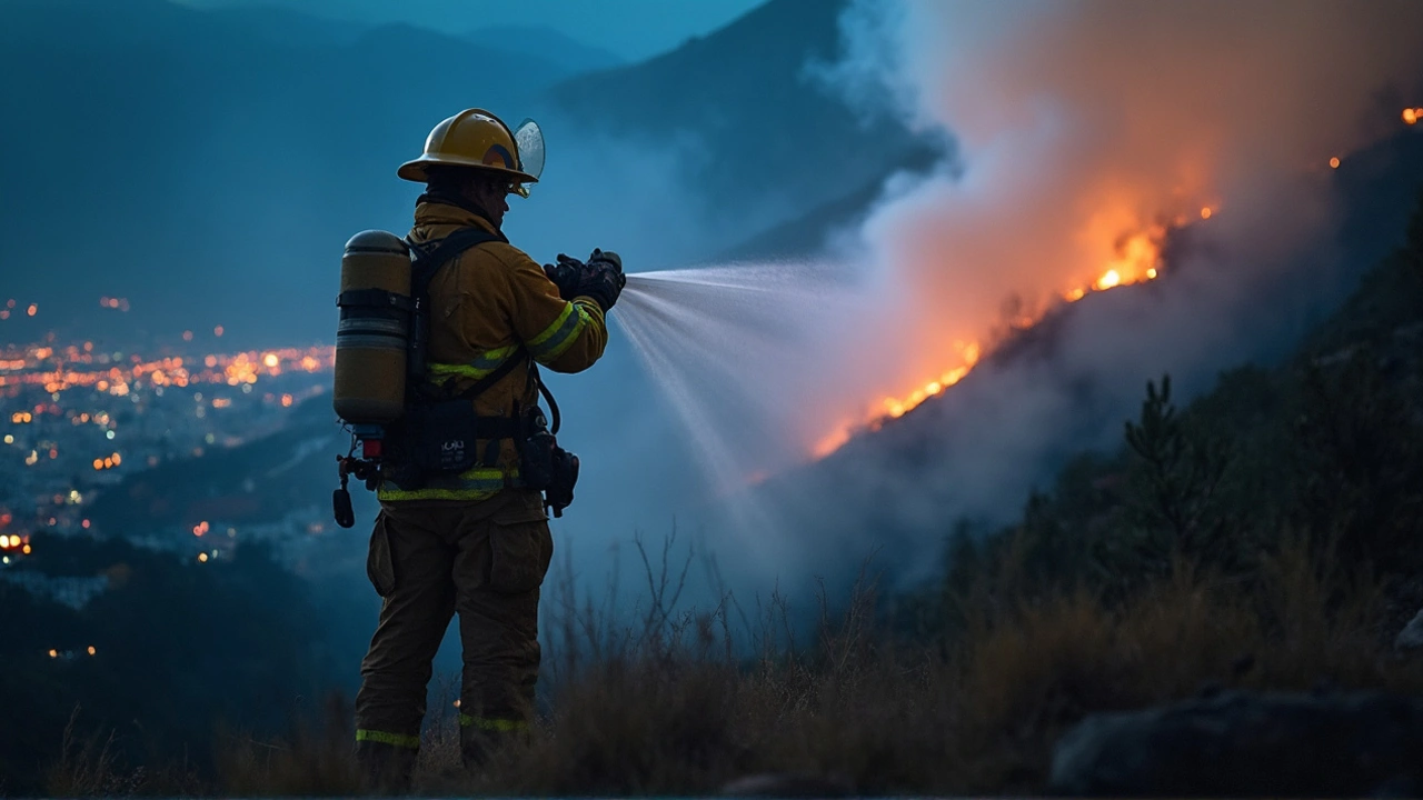
Firefighters, who have barely caught their breath, are keeping their boots laced and hoses ready. The blaze kicked off on a tense Sunday, fueled by blustery winds and dry brush around Newlands. In a matter of hours, tongues of fire tore through the green belt, creeping into the City Bowl and reaching the edges of Red Hill, Ocean View, and Kommetjie. It’s a gut-punch for locals who remember previous fires that left scars on the mountain and the city.
Emergency teams from across Cape Town were pulled in. On the ground, dozens of firefighters trudged through rough terrain while choppers swooped overhead, dousing hot spots before they could flare back up. Wind changes made the job even harder—a sudden gust would send embers leaping towards new areas, forcing teams to shift strategy on the fly.
Helicopters, Ground Crews, and a Watchful Public
Unlike some big blazes in the past, so far there’s huge relief: no homes lost and, more crucially, no lives. The credit for that goes to the rapid response from firefighting crews and the extra muscle from aerial teams. Their focus now is tracking those unpredictable flare-ups. Hot, dry weather can make small embers grow into major threats in minutes.
That’s why restrictions on mountain access are still in force. Officials haven’t just closed trails for the fun of it. Firefighters need open paths and clear spaces to move their gear and respond if things escalate again. There’s real frustration among avid hikers and dog walkers, but as fire authorities put it, the risk just isn’t worth it right now.
To keep things under control, crews are using spotters and thermal cameras to identify fresh heat patches. The helicopters, easily recognized by locals, aren’t just for dramatic effect—they’re lifelines, ferrying water to places that ground teams can’t reach. It’s careful, nerve-wracking work that demands patience and constant attention to detail.
While the bulk of the flames are down, no one wants to call the fight over until the last ember is out. Table Mountain’s iconic slopes have been here longer than any of us, but fire season is a yearly reminder of just how tough it is to keep them safe. The message from the frontlines right now: let the crews do their job, respect those closed trails, and keep an eye out for official updates. After all, Cape Town’s wild spaces are only as protected as the people who guard them.


Lizzie Fournier
April 28, 2025 AT 19:24Seeing the crews keep their gear ready reminds us all that wildfire safety is a shared responsibility. The firefighters’ vigilance on Table Mountain sets a strong example for hikers and residents alike. It’s great that the authorities kept the trails closed to give crews clear access. Respecting those restrictions helps prevent flare‑ups before they start. Let’s all spread the word and support the teams on the ground. Together we can keep Cape Town’s natural gems safe.
JAN SAE
May 12, 2025 AT 16:44Wow, the coordination between aerial drops, ground crews, and incident command was nothing short of spectacular, and the way each unit pivoted with the wind changes was truly impressive, kudos to every firefighter, pilot, and volunteer who stayed on alert, you all rock!!!
Steve Dunkerley
May 26, 2025 AT 14:04The operational posture adopted during the Table Mountain incident aligns closely with the Incident Command System (ICS) framework, wherein the command, operations, planning, logistics, and finance sections synergized to achieve rapid containment. Initial attack strategies prioritized direct attack using handheld pumps and portable water tanks, followed by indirect attack via aerial retardant drops to create fire‑line buffers. Fire behavior analysts monitored real‑time flame length, rate of spread, and heat release rate, feeding these metrics into predictive models to anticipate potential ember showers. The prevailing wind shear, measured at 20 km/h with gusts up to 35 km/h, necessitated dynamic repositioning of resources, a maneuver facilitated by the mobile command post stationed at Newlands. Ground crews employed fire‑break construction techniques, manually clearing combustible material to a width of 5 meters, thereby reducing fuel continuity. Simultaneously, helicopters equipped with Bambi‑bucket systems delivered approximately 8,000 liters of water per sortie, targeting hotspots identified via infrared thermal imaging. The integration of GIS mapping allowed incident commanders to visualize hot‑spot clusters and allocate assets with spatial precision. Communication protocols adhered to the Standard Operating Procedure (SOP) for inter‑agency radio traffic, minimizing latency in information exchange. Logistic units maintained a continuous supply chain of personal protective equipment (PPE), potable water, and nutrition to sustain crew endurance during extended operational periods. Safety officers conducted frequent risk assessments, enforcing look‑out‑left‑right (LORL) checks and monitoring crew fatigue levels. Post‑incident debriefs emphasized lessons learned regarding ember transport mechanisms, leading to refinements in future prescriptive fire‑danger rating calculations. Community outreach teams disseminated public advisories through social media platforms, reinforcing the importance of staying off restricted trails. The collaborative effort showcased the efficacy of a multi‑disciplinary response, underscoring that no single element-be it aerial support, ground suppression, or public cooperation-can succeed in isolation. As a result, the fire remained largely constrained, preventing property loss and preserving human life. Continued vigilance remains essential, as residual heat pockets can reignite under favorable conditions, and the incident serves as a testament to the value of preparedness and coordinated action.
Jasmine Hinds
June 9, 2025 AT 11:24Stay safe out there 😊
Madison Neal
June 23, 2025 AT 08:44The rapid deployment of incident command resources exemplifies best‑practice fire suppression tactics, and I appreciate how the operation integrated predictive fire modeling with on‑the‑ground situational awareness. By employing both direct and indirect attack methods, crews maximized fire‑line effectiveness while minimizing ecological impact. The use of thermal imaging to locate residual heat signatures highlights the importance of technology in modern wildfire management. Such coordinated efforts not only protect lives but also preserve the biodiversity of the Table Mountain ecosystem.
John Crulz
July 7, 2025 AT 06:04I admire how the collaborative framework balanced aggressive suppression with respect for the natural landscape, showcasing that community resilience and professional expertise can coexist harmoniously.
Anita Drake
July 21, 2025 AT 03:24Recognizing the cultural significance of Table Mountain for the indigenous Khoi Khoi and San peoples adds another layer of responsibility; protecting this landmark honors both ecological and heritage values, fostering a shared sense of stewardship across all communities.
Eduardo Lopez
August 4, 2025 AT 00:44The sheer drama of helicopters carving arcs over the ignited slopes, coupled with the roar of pumps echoing through the canyon, reads like a cinematic masterpiece-yet it is the quiet dedication of each crew member that truly steals the spotlight.
Nancy Perez de Lezama
August 17, 2025 AT 22:04The authorities acted appropriately by maintaining trail closures; such measures are essential to ensure safety and allow fire crews unobstructed access to critical zones.
Matt Heitz
August 31, 2025 AT 19:24From a national security perspective, safeguarding Table Mountain is paramount, as its prominence in our cultural identity demands unwavering protection; the deployment of advanced suppression assets underscores our commitment to defending vital terrain against natural threats.
Susan Mark
September 14, 2025 AT 16:44For anyone planning to venture near the area once the fire is fully out, ensure you carry an updated map, check the latest satellite fire‑risk advisories, and always inform someone of your route; preparedness can make the difference between an enjoyable hike and an avoidable emergency.
Jason Jennings
September 28, 2025 AT 14:04Looks like another fire was handled alright, nothing too surprising.